
A multi-scale framework for erosion assessment and mined land rehabilitation
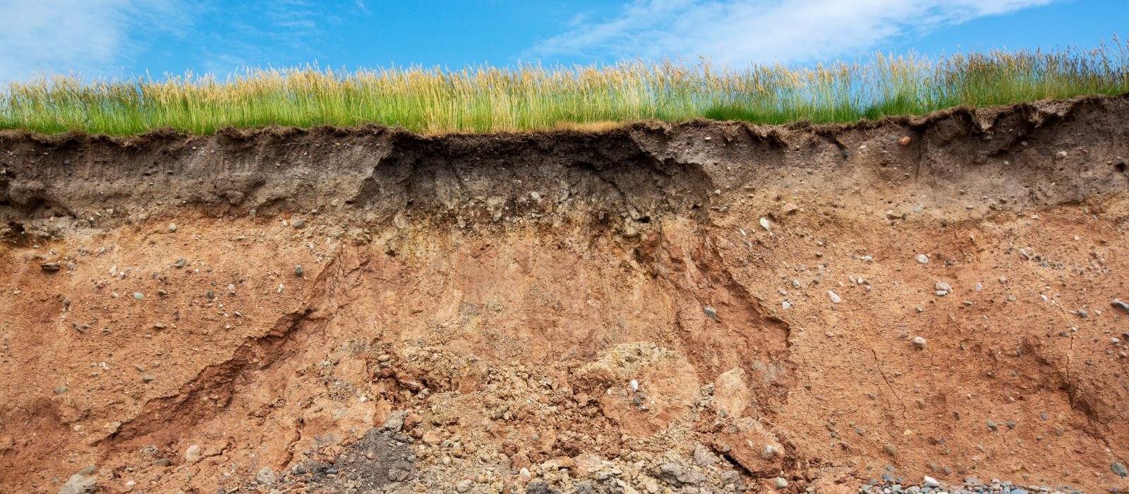
The geomorphic complexity of post-mining landscapes
Erosion is a fundamental natural process, yet it is often significantly accelerated by anthropogenic activities, particularly within the intensive landscapes of the mining sector. Developing an understanding of erosion rates is not merely a scientific pursuit but a practical necessity for formulating effective management strategies, engineering stable new environments, and predicting the long-term environmental trajectories of rehabilitated land once mining operations have concluded.
As a geomorphic phenomenon, erosion is inherently complex, driven by a multifaceted interplay between rainfall kinetic energy, surface runoff hydraulics, intrinsic material properties, topographical relief, and successional vegetation cover. These interactions manifest across a vast spectrum of spatial and temporal scales, and critically, the specific scale at which erosion is observed and measured fundamentally influences the resulting data and its practical applicability.
This article examines the critical importance of scale-dependency in erosion assessment. By comparing and contrasting methods that can be used at the laboratory scale, the local field scale, and the macro-field scale, we explore how a nested observational hierarchy is essential for capturing the full scope of landform evolution.
Micro-scale analysis: screening and material characterisation
Laboratory analysis can be used to screen materials by evaluating the interplay between physical structure, hydraulic behaviour, and chemical stability. Particle size analysis establishes a physical baseline, identifying silt-heavy erodible textures that lack cohesion. However, physical grading alone can be deceptive; the Emerson aggregate test and calcium to magnesium ratio (Ca:Mg) expose the invisible chemical risk. The Emerson aggregate test provides a critical qualitative interpretation by observing how aggregates react in distilled water. If an aggregate rapidly collapses, it is classified as slaking, and if a cloudy suspension follows, it is also highly dispersive, indicating risk of surface sealing and tunnel erosion.
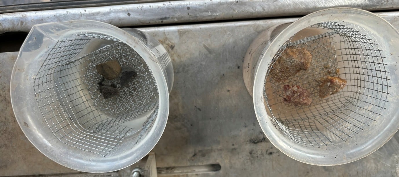
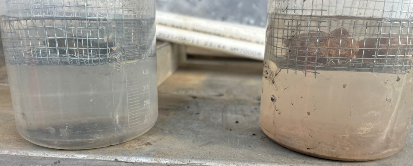 Example of slaking sample on the left, dispersive sample on the right.
A Ca:Mg ratio below 2:1 often drives this behaviour, as magnesium causes clay particles to repel each other. This vulnerability is quantified by the double hydrometer test, which measures the proportion of particles that disperse naturally versus those forced apart chemically. Finally, the pinhole test serves as the ultimate hydraulic stress test, determining if dispersed particles will actually be transported under flow. Together, these tests tell a useful story: the particle size identifies if the material can be moved, the chemistry and Emerson aggregate test determine if it wants to fall apart, and the pinhole and double hydrometer tests predict how fast it will fail under pressure. However, the story is limited because analytical analysis measures erodibility (sensitivity to detachment), but in a rehabilitated landscape, we are dealing with erosion (complex, integrated movement of material).
Controlled process simulation: isolating hydraulic drivers
Laboratory-based methods provide highly controlled environments necessary to deconstruct complex erosion mechanisms into their fundamental hydraulic and mechanical components. By isolating specific variables, a laboratory can quantify the mechanics of erosion loss with a level of precision that is unattainable in the stochastic and unpredictable theatre of a rehabilitated landscape.
Central to this approach are rainfall simulators: apparatuses designed to apply artificial rainfall with controlled kinetic energy, through the regulation of intensity, duration, and drop size distribution. When these simulated events are applied upon specialised trays, they are used to quantify splash erosion, infiltration capacity (effective hydraulic conductivity), and the initiation of interrill runoff. Because parameters such as gradient, texture, antecedent moisture, and surface roughness can be systematically manipulated, these simulators measure shear stress thresholds at which a stable material begins to erode. Complementing this is overland flow flumes — engineered channels that introduce water at precise discharge rates over a prepared material bed. These flumes shift analytical focus from raindrop impact to the fluid dynamics of shallow flow, facilitating study of rill formation, sediment transport capacity, and specific hydraulic forces that control detachment.
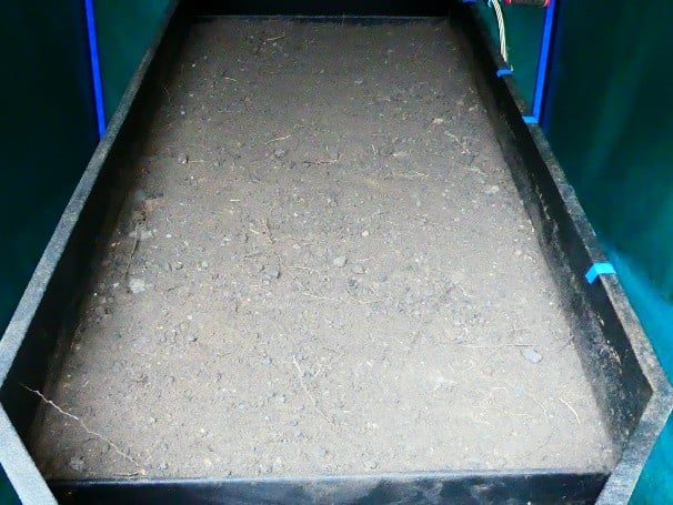
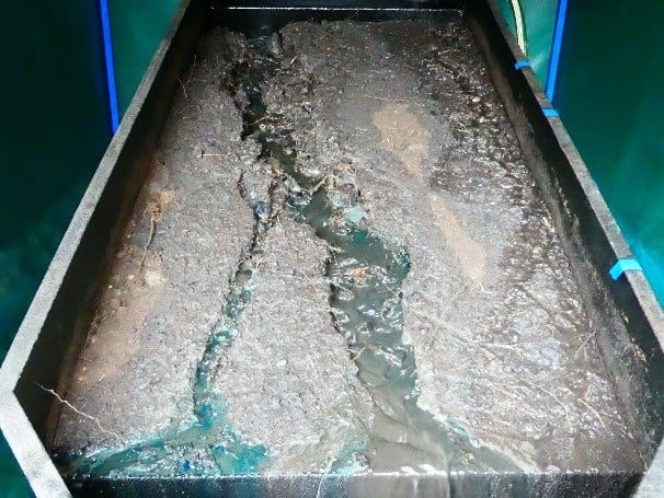
Example of an overland flow flume showing a prepared bed on the top and eroded surface on the bottom.
The primary advantage of controlled process laboratory analysis lies in repeatability of experiments and the capacity to isolate competing processes, such as distinguishing the detachment energy of splash erosion from the tractive force of sheet flow. This modularity makes this type of testing an exceptionally efficient way to analyse a wide spectrum of boundary conditions that would take years to observe in situ. However, this precision is accompanied by significant limitations, most notably the scale effect. Results derived from controlled process analysis often suffer from boundary interference, and a lack of topographical complexity, making extrapolation of measured erosion rates to the landscape scale problematic, often resulting in over estimation of erosion.
Furthermore, the representativeness of laboratory scale data is also constrained by the use of disturbed samples, which fail to mirror the complex structural integrity of the rehabilitated environment. When material is extracted and stripped of its in situ profile, intricate root architecture, and biological macropores, the resulting sample becomes a homogenised shadow of its in situ state. Consequently, such samples cannot accurately replicate critical in situ phenomena – such as the formation of protective surface crusts or the development of preferential flow paths – which control how water and sediment move through the rehabilitated landscape.
Meso-scale monitoring: high-resolution characterisation of discrete landforms
Shifting from laboratory to field scale, targeted monitoring bridges the gap between analytical and process isolation to landscape-scale complexity. This type of assessment concentrates on specific geomorphic units or features, such as individual hillslopes, active gullies, or trial plots, typically operating at a spatial resolution of meters to tens of meters. Within these discrete zones, high-resolution digital stereo-photogrammetry can be used as a robust, non-invasive method for measuring erosion. By establishing a baseline and capturing overlapping imagery from georeferenced positions a high-fidelity three-dimensional digital elevation model (DEM) can be generated.
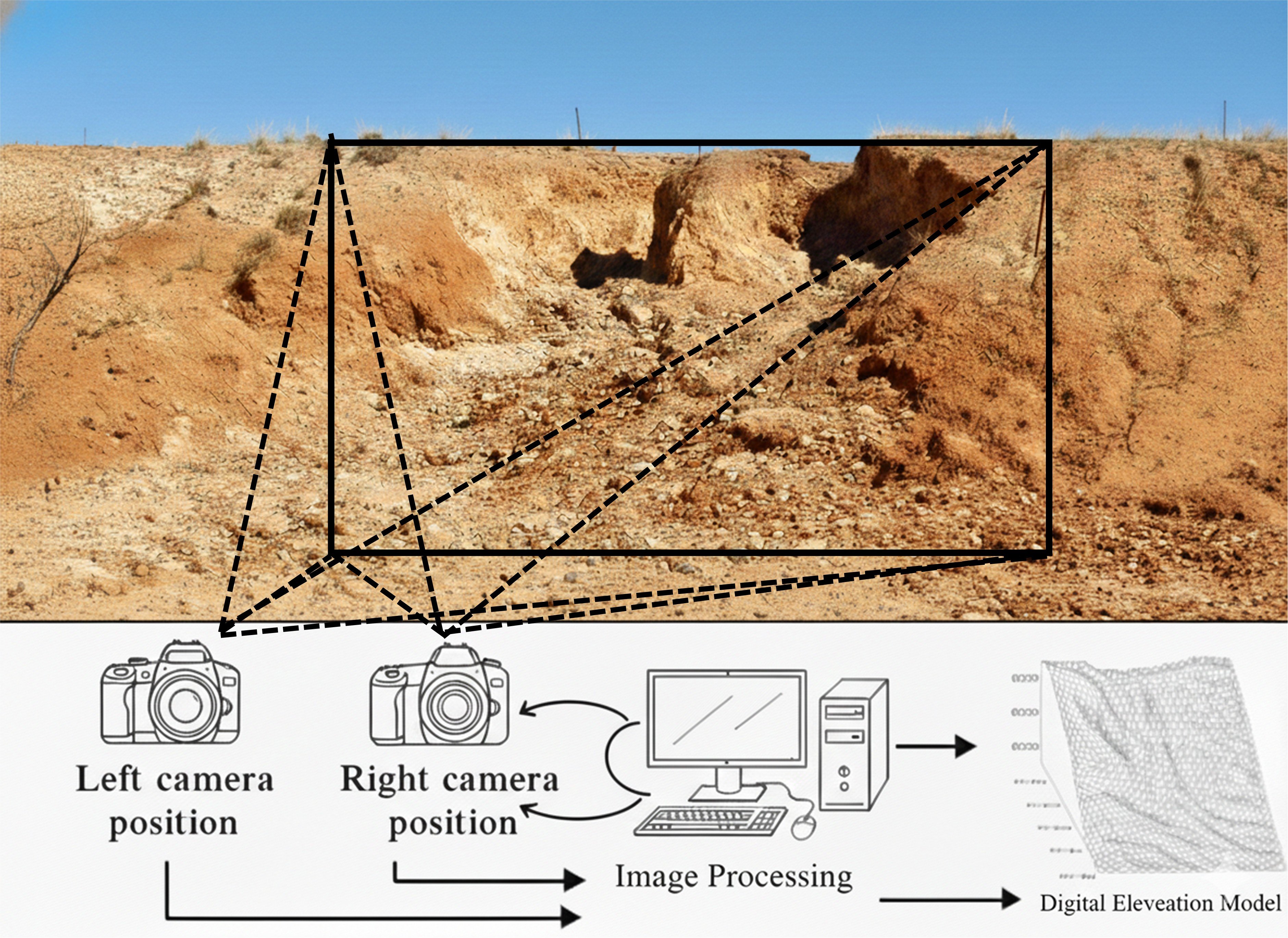
The stereo photography process.
The analytical strength of this technique lies in its capacity for volumetric change detection. Through multitemporal comparison of surface models, this technique achieves precise quantification of material detachment or deposition within a targeted feature. This photogrammetric approach offers distinct advantages over traditional mechanical methods, such as erosion pins or bounded collection troughs, as it eliminates the risk of localised disturbance and hydraulic interference associated with physical instrumentation. Furthermore, the high-resolution nature of the imagery can facilitate estimation of surface particle size distribution, providing a secondary layer of data regarding sediment availability.
However, high spatial resolution of targeted monitoring is counterbalanced by restricted spatial coverage. While this method provides deep insight into point-source erosion, it does not capture the more diffuse, broader processes – such as sheet erosion – that could occur on the inter-feature surfaces of large rehabilitated landforms. Additionally, the efficacy of stereo-photogrammetry is highly sensitive to occlusion of the gully by itself, ground cover and ground-level biomass; dense vegetation can obscure the ground surface, potentially introduce significant error or require the relocation of monitoring sites. Consequently, while this field-scale technique provides data for extending laboratory scale analysis under natural conditions, the results represent a localised maximum that must be carefully weighted when extrapolated to the rehabilitated landscape scale.
Macro-scale assessment: quantifying landscape-level sediment flux
Macro-scale studies shift the investigative focus toward quantifying sediment dynamics over expansive landforms, including entire rehabilitated waste rock dumps, and tailings storage facilities spanning several kilometres. At this scale, LiDAR (Light Detection and Ranging)—deployed via aerial or unmanned aerial vehicle (UAV) platforms—serves as the primary instrument for acquiring high-resolution topographic datasets across extensive spatial extents. Multitemporal comparison of LiDAR-derived DEMs can quantify geomorphic evolution via a process of co-registration and subsequent DEM subtraction.
This DEM of difference approach allows for spatial identification of negative elevation changes (erosion) and positive accumulations (deposition). By integrating these volumetric shifts across the landform surface, total sediment yields and area-weighted average erosion rates can be calculated, provided that non-erosional volumetric changes – such as autogenous consolidation, settlement, or subsidence – are analytically isolated and excluded. In conjunction with LiDAR, multispectral scanning can be used to map vegetation density and groundcover percentages. Given that vegetation acts as a critical moderator of erosion – by increasing hydraulic roughness, enhancing infiltration, and providing mechanical reinforcement – these data are essential for calibration of physics-based erosion models, such as the Water Erosion Prediction Project (WEPP) or Landform Evolution Models (LEMs). These integrated datasets enable the simulation of long-term landform stability under diverse climatic and successional vegetation scenarios.
A significant advantage of LiDAR is its last return capability, which allows the laser pulse to penetrate vegetative canopies to reach the underlying soil surface, thereby providing a spatially contiguous ground model that integrates the cumulative effects of disparate erosion processes.
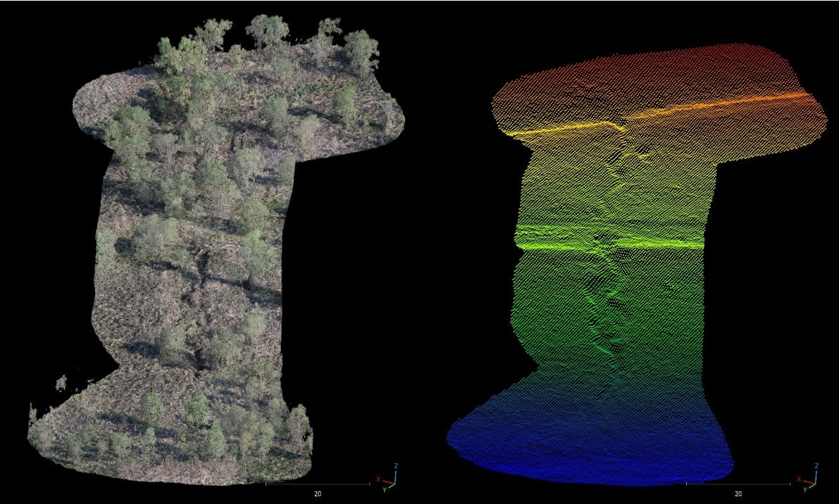
Example of high-resolution cloud data for an erosion gully under vegetation cover.
Despite the spatial coverage offered by macro-scale monitoring, the method is subject to technical constraints. Spatial resolution is maybe coarser than localised photogrammetric methods, which may result in a failure to resolve nascent rill networks or subtle micro-topographic changes. Furthermore, the reliability of DEM differencing is highly contingent upon the precision of co-registration and the signal-to-noise ratio of the sensors; minor vertical errors can propagate into significant volumetric inaccuracies if not corrected. While this landscape-scale assessment technique provides the requisite average erosion rates for regulatory compliance and broad structural planning, they can potentially mask localised hotspots of instability. Nonetheless, macro-scale analysis is a fundamental tool for validating theoretical models against real-world rehabilitated landscape evolution.
Discussion: The importance of scale integration
Scale comparison presented in this article underscores a fundamental principle in geomorphology: no single observational scale provides a complete diagnostic of erosion dynamics. Laboratory analyses are necessary for isolating fundamental mechanical processes, yet they lack the boundary conditions necessary to predict field-scale flux. Local field-scale monitoring—utilising techniques such as stereo-photogrammetry—excels at quantifying high-magnitude features like gullies but fail to capture the broader landform context. Macro-scale assessments using LiDAR provide the requisite average rates and landscape connectivity, but frequently lack the resolution to resolve specific process-driven hotspots.
Erosion rates are inherently scale-dependent; processes that dominate the sediment budget at one spatial resolution may become negligible at another. For example, interrill flow may govern detachment on rainfall and flume simulations, gully incision becomes the primary driver of erosion loss at the local field scale, and cumulative landscape evolution emerges at the macro scale. Relying on a single scale for long-term prediction of erosion and rehabilitated landform evolution can lead to significant predictive errors.
Conclusion: toward an integrated predictive framework for closure
In the context of mined land rehabilitation, the transition from active operations to a sustainable, post-mining landscape represents a complex geomorphic challenge. The ultimate goal of rehabilitation is to ensure landform resilience, yet achieving this requires moving beyond static design assumptions toward a dynamic, multi-scale evidentiary framework.
A robust predictive capability is not a luxury but a prerequisite for relinquishment and risk mitigation. As demonstrated throughout this technical review, achieving this capability requires the integration of observations across a multi-scale hierarchy. Laboratory data are essential to parameterise fundamental physical equations within numerical models, defining the inherent erodibility of cover materials. Local field-scale monitoring, such as stereo-photogrammetry, then serves to validate these model predictions against specific high-risk landform features like steep batter slopes or drainage confluences. Finally, macro-scale datasets—derived from LiDAR and multispectral imagery—provide the critical topographic and vegetative boundary conditions necessary for landscape evolution modelling.
For the mining industry, the value of this integrated approach lies in its ability to identify design failures before they manifest as environmental liabilities. By linking the microscopic mechanics of the laboratory to the macroscopic reality of the watershed, closure practitioners can design managed landform environments that do not merely resist erosion in the short term, but evolve toward a state of geoformed equilibrium. This multi-scaled synthesis provides the only credible path toward demonstrating that a rehabilitated landform will remain stable and functional over the centennial timescales required for successful relinquishment.