
Want to better represent the subsurface? Try combining implicit and explicit geology modeling

It’s not easy to transform raw geoscience data into reliable geological models of the subsurface no matter what modeling software you use.
Explicit geology modeling methods are better at some things, and implicit modeling methods are better at others. But who says you have to use just one?
Traditionally, geologists have made their geology models explicitly. It’s a method they like because it allows them to fully control the geology: they can simply display their data and immediately start digitising polygons, points, or triangles to create a model that represents their understanding of the subsurface.
This full control comes at a cost, however.
Explicit modeling is often manually intensive. It can take hours for geologists to digitise wireframes, create and validate meshes, etc. Plus, because it requires skill to wield the software needed to generate a model, as well as knowledge of a host of functions, it is fully dependent on the expertise of an individual user. There is no guarantee that a different geologist, even on the same team, could regenerate the same model or get the same output.
The arrival of implicit geology modeling in recent years has brought obvious benefits. It’s fast, parameter-driven and easy to update, plus it has good traceability and it’s repeatable and accessible. However, it also offers geologists less control than they’re used to with explicit modeling, which is particularly important for high-value deposits or complicated geotechnical structures. It is also often black box, with little visibility for geologists to ‘see’ the modeling process within.
In addition, with implicit modeling, geologists often have to take time to significantly prepare or code the data up front, which can slow down the modeling process — in some cases, effectively making implicit modeling methods no faster than explicit modeling methods.
But what if geologists did not have to choose between one modeling method or the other? What if they could have the control of explicit modeling with the repeatability, automation, and traceability of implicit modeling?
Integrated implicit and explicit geology modeling
GEOVIA’s Integrated Implicit and Explicit Geology Modeling enables geologists to use our implicit modeling software, the GEOVIA Geology Modeler, within our explicit modeling software, GEOVIA Surpac. From there, they can take advantage of the strengths of each method without any of the weaknesses and adapt their modeling to suit any geological scenario or setting.
Case study: how it works
Any geologist with GEOVIA Surpac can use Surpac POWER’BY to access the GEOVIA Geology Modeler, which sits on the 3DEXPERIENCE platform, to generate implicit geology models in a linear workflow that uses three applications:
- Geoscience Data Administration allows geologists to configure the underlying borehole data model within the Geology Modeler by defining attributes and measurements (data types). It also helps the Geoscience Data Administrator manage and organise geoscience data (borehole and point data) into geoscience datasets for easy access. When new data is added, the app validates it by using ingestion reports and the Geoscience Data Administrator can control when the data is released, ensuring only approved geoscience data is used for geological modeling tasks.
- Geoscience Interpretation allows geologists to open and visualise geoscience datasets in either 2D or 3D. They can then customise the appearance of the data by adding downhole labels, symbols, and colors. They can also easily create interpretations, from downhole composites for grade-shell modeling to complex rules-based classifications for re-code intervals that leverage multiple attributes while considering spatial relationships between intervals. This is highly significant because it helps geologists re-code lithology intervals to meet a certain stratigraphic sequence or interpretation.
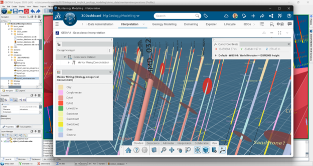
Figure 1: The Geoscience Interpretation app, within GEOVIA Surpac.
- The Geology Modeling app makes it possible for geologists to consume and leverage explicit data generated from GEOVIA Surpac within the implicit modeling process.
It centralises and associates all terrain and geoscience data in one place and enables geologists to set the size and extent of the geology model. It also, through geochronology definition, considers the order of geologic structures and units over time to reflect the deposit genesis (youngest to oldest), which ensures that the geology model provides an accurate digital twin of the sub-surface geology and geological units clip/cut against each other as they do in the field.
Geology Modeling also leverages a Radial Basis Function (RBF) algorithm along with fixed and dynamic anisotropy, which empowers geologists to generate complex geology models in a matter of minutes or seconds. In addition, server-side processing eliminates the need to stay logged-in while models are generated, giving geologists more time in the field to focus on other tasks.
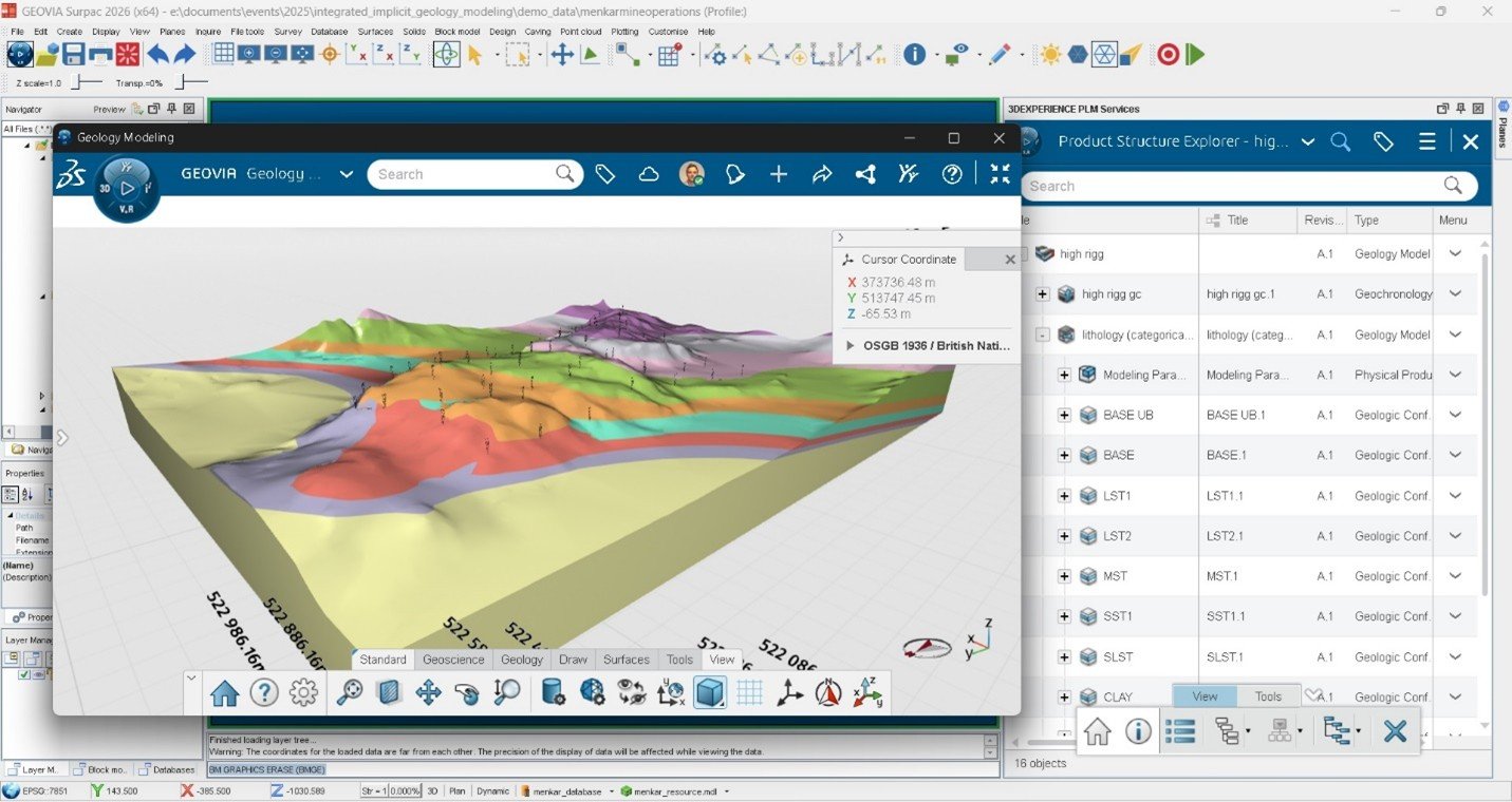
Figure 2: Example of a GEOVIA Surpac geology model.
Four-step integrated workflow
It takes just four steps for a geologist to integrate GEOVIA Surpac and the GEOVIA Geology Modeler:
Step 1: Connect your Drillhole Management System to both Surpac and the Geology Modeler. This direct connection ensures you will always have access to the latest data when it arrives at your DMS.
Step 2: Generate explicit data, such as ore bodies or intrusion solids, outcrop or wireframe polygons, and surfaces such as terrains, faults, and unconformities, within GEOVIA Surpac, then upload that data to the Geology Modeler via the Surpac POWER’BY interface.
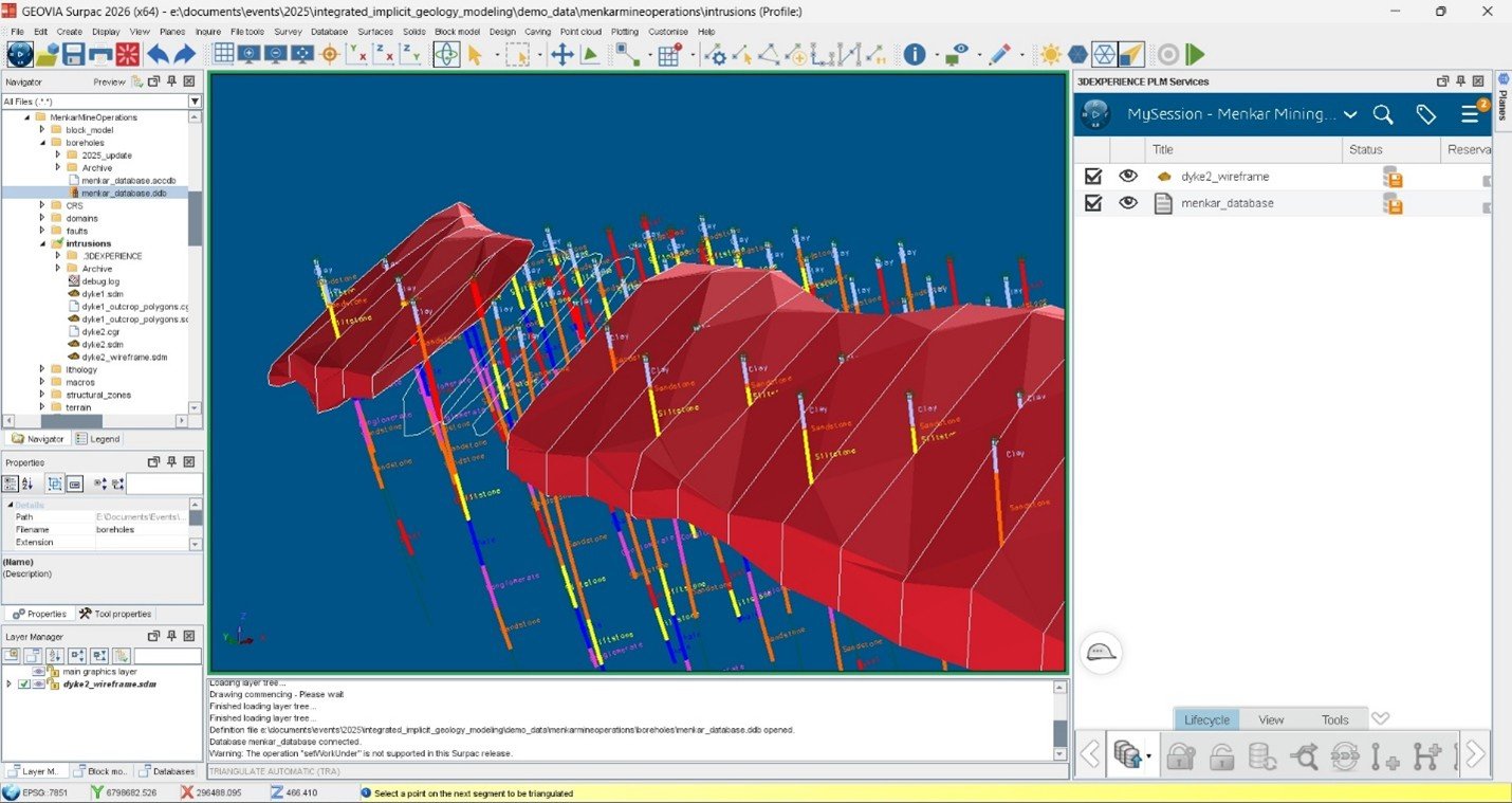
Figure 3: Example of a GEOVIA Surpac geology model.
Step 3: Set parameters for model extents, geochronology, and modeling parameters before generating the Geology Model from within the GEOVIA Surpac interface, by using Surpac POWER’BY and the Geology Modeling application.
Step 4: Drag and drop the combined implicit/explicit geology model back into GEOVIA Surpac, where Surpac validation checks on the solids or surfaces will ensure the model meets geological and data standards.
The finer details
With GEOVIA’s integrated Implicit and Explicit Geology Modeling, geologists can
choose whether geological surfaces and/or solids are generated explicitly within GEOVIA Surpac or implicitly within the GEOVIA Geology Modeler, and can quickly centralise and model all geoscience data, regardless of its source, in a single process. They can also model any type of deposit, from simple layer cake stratified deposits, to complex multi-faulted stratified units, to challenging orebodies with complex geomorphology, and easily add additional explicit data at any time and update the model in a matter of minutes.
In addition, this method gives geologists the ability to ingest explicit polygons or polylines into the modeling engine to better control the outcrop pattern of a geological unit, orebody, or intrusion, and it supports cross-sectional interpretations that help geologists regain crucial control over their implicit geological models and meet the interpretations they have defined.
GEOVIA Integrated Implicit and Explicit Geology Modeling also:
- allows explicit solid integration so geologists can ingest and leverage explicit solids representing ore bodies and/or intrusions within the implicit Geology Modeler’s geology model workflow
- provides two faulting methods: localised faulting and structural zone faulting, so geologists can model pretty much any faulting scenario: normal faults, reverse faults, strike-slip faults, and true local faults
- leverages point data within the modeling process to generate implicit terrain, fault, trend, or unconformity surfaces, and can influence stratified bedding and faults through downhole or point data structural measurements, and
- gives geologists the choice to use either fixed or dynamic anisotropy in surface/solid mesh generation when modeling conformable units, orebodies, or intrusions, which ensures geological trends seen in the field or the data are followed and accurately replicated in the geology model to help create a true digital twin.
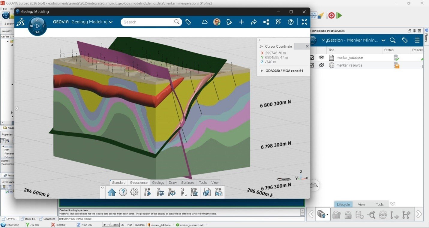
Figure 4: Example of a complex geological scenario created in the GEOVIA Integrated Implicit and Explicit Geology Modeling solution.
Find out more: If you’re interested to learn more, we invite readers to join the GEOVIA User Community by Dassault Systèmes, to read about industry topics from experts. All industry professionals are welcome to learn, engage, discover, and share knowledge to shape a sustainable future of mining.