
Behind Western Australia’s first successful pit lake closure: Lake Kepwari
A rehabilitation case-study that demonstrates how cooperation between mining companies, the local community and government can help ensure a positive environmental, social and economic outcome
Introduction
The Collie Coal Basin is the centre of the coal mining industry in Western Australia and is located approximately 160 km south-south-east of Perth. More than 100 years of coal mining in Collie has resulted in the formation of at least 13 pit lakes as a lake district (sensu McCullough and Van Etten, 2011) with differing water quality and extent of rehabilitation. All are acidic due to moderate acid and metalliferous drainage (AMD) production from oxidation of the regional low sulfide lithologies (McCullough et al, 2010). One of these pit lakes is the WO5B mine void, which was rehabilitated and integrated into the Collie River South Branch as Lake Kepwari.
Waterways in south-western Western Australia, including the Collie River, continue to play an important role in the lives of Nyungar people; their connection to the Collie River is reflected in their spiritual beliefs and its role as a source of food, water and recreation (Brad Goode and Associates, 2012). The aims for Lake Kepwari were to provide a recreation resource for water skiing, diving and other aquatic recreational pursuits. Kepwari is a word in the Indigenous Wilman language meaning 'playing in water', and all manner of water sports will be enjoyed at Lake Kepwari for generations to come.
Background and development
Mining began in the Western No 5 open-cut area in the 1970s with a number of pits including WO5B. Diversion of the Collie River South Branch (CRSB) around the western margin of WO5B in 1990 (Figure 1) enabled access to unmined coal reserve beneath the river. Rehabilitation works on WO5B initially started in the 1980s in parallel with open-cut mining operations. When mining ceased in 1997, most reactive overburden dumps and exposed coal seams were covered with waste rock to cover potentially acid forming (PAF) sources. The WO5B mine void edges were backfilled and graded in some areas to form beaches and an island, and then extensively revegetated with native flora by direct seeding more than 60 species of native vegetation. The diversion channel was then maintained to permanently divert the CRSB around the WO5B pit void, meeting the requirements of the 1997 Mine Closure Plan for a ‘closed catchment lake’.
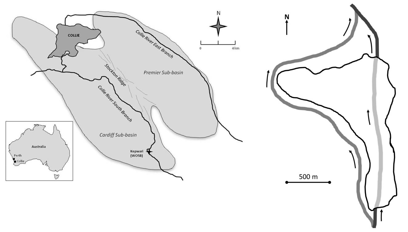
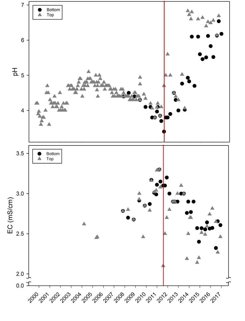
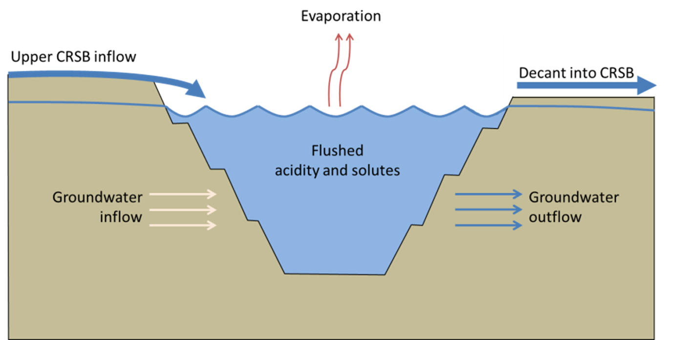
A key challenge of this rehabilitation plan was that the mine void would take 100 years to naturally fill with groundwater. However, this time frame was reduced considerably by providing additional water by extracting saline first flushes from the seasonal CRSB through a surface water license (Salmon et al, 2017). To accelerate filling of the pit, the lake was rapid-filled by seasonal diversions from the CRSB over the winters between 2002–08 through a valve-regulated offtake in years when river flow was sufficiently high. CRSB water quality is typically brackish and highly tannin stained, with moderate eutrophication. The lake reached its capacity volume, as limited by overflow culverts, in 2004 and was named Lake Kepwari. The volume of Lake Kepwari is around 32 × 106 m³, with a maximum depth of around 65 m, perimeter of 5.4 km and surface area of 1.0 km² (Lund et al, 2012).
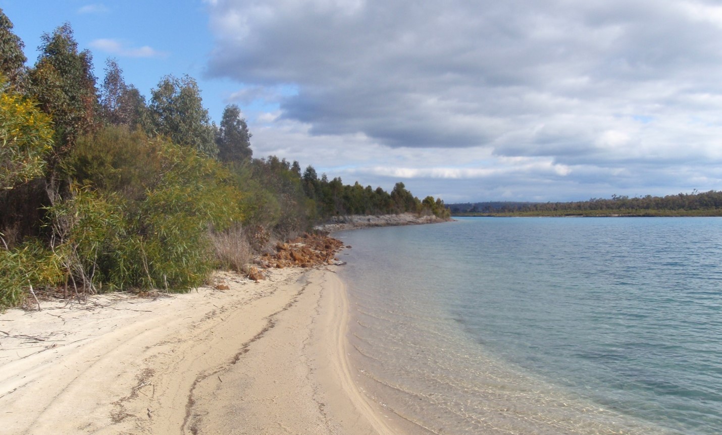
Although the input of CRSB water initially raised the pH to above pH 7, the pH then fell below 4 once river inflows ceased. This low pH and associated elevated concentrations of some metals and metalloids reduced water quality values and restricted end use opportunities. However, the lake remained visually spectacular with extremely high transparency due to an absence of phytoplankton, restricted by low phosphorus due to AMD (Kumar et al, 2016) (Figure 2).
Breach event
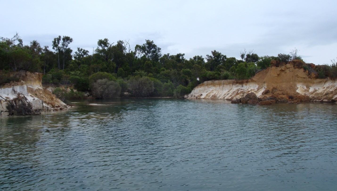
Heavy rainfall in August 2011 led to the CRSB overtopping the diversion channel and the embankment that separates it from Lake Kepwari. Approximately 30 m of ground failed, and 2 GL of CRSB water flowed through Lake Kepwari, decanting through culverts in the north-east and north-west sides of the Lake (Figure 3; McCullough et al, 2013). This unintentional flushing had the effect of substantially improving the water quality and ecosystem values (McCullough et al, 2012), indicating that maintaining the lake as a flow through system would likely provide a leading practice closure strategy for the lake.
A literature review at the beginning of the project, coupled with early and regular engagement, provided confidence to stakeholders that the approach was leading international practice. Following broad stakeholder engagement, including community presentations, and approval by state regulators, a flow-through trial was initiated to assess the benefits of this leading practice management option. The trial was run between 2012 and 2014, with over two years of flow and one year of no flow due to low rainfall. Regular quarterly assessment of biota and chemistry of both Lake Kepwari and the CRSB, and annual reporting of the findings to regulators and community, were key components of the trial.
The monitoring results showed that downstream river water quality is not significantly degraded by flow-through, since the greatest decant volumes occur predominantly during high CRSB flow with consequent high lake water dilution (McCullough and Schultze, 2015). Further, river water quality may actually be improved (relative to upstream) through trapping of sediment, including particulate forms of nutrients by the lake benthos, and removal of soluble forms of phosphorus by co-precipitation with dissolved aluminium species present with lake AMD (McCullough and Schultze, 2018). Monitoring indicates that, following implementation of flow-through, lake pH is higher than historic levels, and importantly, on an upward trend (Figure 4). The monitoring period validated the closure approach such that the project was listed as a case study in pit lake management before relinquishment (DIIS, 2016).
AMD produced in the backfilled waste rock and pit shell is neutralised by net alkaline river water by regular seasonal flow-through. Further alkalinity is generated by biological processes (especially algal growth) (Lund and McCullough, 2009) and some acidity in the form of aluminium and iron is precipitated to lake sediments (Neil et al, 2009). The net result yields a seasonal thermally stratified freshwater lake of circum-neutral pH (Figure 5). Lake Kepwari is now part of the Collie River Waugal Aboriginal Heritage Site, which includes all of the Collie River system.
Lake Kepwari relinquished
As a result, Premier Coal applied for approval to permanently divert the Collie River back to its original path through the mine void. Recent rehabilitation activities to facilitate permanent flow through included widening the Collie River inlet and outlets to allow full flow through the lake; rehabilitating the breach; and backfilling the diversion channel. Premier Coal engaged local businesses that employed local people to do this work. This permanent flow-through of the Collie River was approved in November 2018 and civil works enabling the flow-through were completed in June 2019.
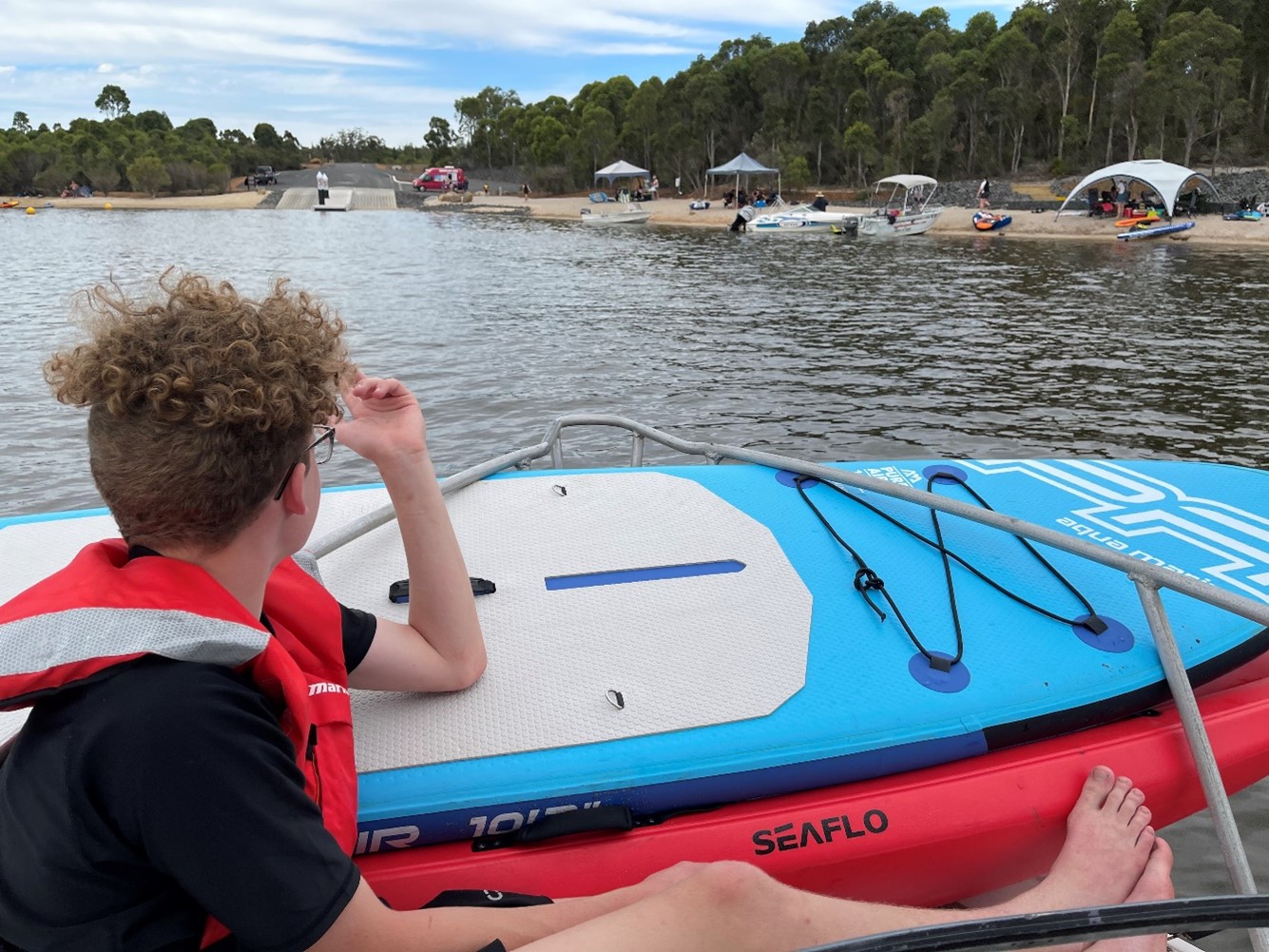
The WA State Government identified Lake Kepwari as a key development project in the South West region and committed $5.7 million to realising this vision. Recent works commissioned by government to develop the lake into a recreation hub included a swim beach, picnic areas, campground, toilets, dual lane boat ramp and jetty, and parking bays for 85 boat trailers and 65 cars. Upgrades to the entrance road, a new bridge over the Collie River and signage throughout the area has turned the area into a water sports landmark.
Collie is a town that has traditionally been reliant on mining and power generation to employ many in the community and to support local businesses. But tourism is becoming an important driver of a more diversified economy for Collie. The enhancement of nature-based tourism will contribute to economic growth and diversification, underpin job creation and a secure a sustainable regional community. The transformation of Lake Kepwari into a recreation hub for water sports is expected to attract an influx of tourists and visitors, which will provide a boost for businesses around Collie. Early estimates anticipate that after three years, Lake Kepwari should attract up to 22,000 overnight stays and 37,000 day trip visitors per annum, contributing millions to the local economy.
Flow-through as a closure practice
Lake Kepwari will be an important landmark for the mining industry, not just for the town of Collie. It is a prime example of how rehabilitating a mine site is more than just planting trees. It demonstrates how cooperation between mining companies, the local community and government ensures mine closure and rehabilitation can have a positive environmental, social and economic impact well into the future.
Flow-through may not work as leading practice for all pit lake closures, particularly those with very high downstream river water quality and end uses and/or restrictions on water availability. The strategy has worked particularly well in the Lake Kepwari pit lake situation because the river channel was able to be maintained in its historical course and was already degraded. This has reduced the risk of AMD on downstream river values. However, like all good mine closure planning, closure of a specific pit lake requires directed technical and supporting studies to provide an evidence-based framework to demonstrate stakeholder-agreed closure objectives are understood and will be sustainably met (McCullough et al, 2020).
References
Brad Goode and Associates (2012). Report of an Aboriginal Heritage Survey for Proposed Breach Repair and Future Works at Lake Kepwari, South of Collie, Western Australia.
DIIS (2016). Leading Practice Sustainable Development Program for the Mining Industry - Preventing Acid and Metalliferous Drainage Handbook Department of Industry, Innovation and Science (DIIS), Canberra, Australia. 221p.
Kumar, R. N.; McCullough, C. D.; Lund, M. A. and Larranãga, S. (2016). Assessment of factors limiting algal growth in acidic pit lakes—a case study from Western Australia, Australia. Environmental Science and Pollution Research. 23: 5915–5924.
Lund, M. A. and McCullough, C. D. (2009). Biological remediation of low sulphate acidic pit lake waters with limestone pH neutralisation and amended nutrients Proceedings of the International Mine Water Conference. Pretoria, South Africa. International Mine Water Association, 519-525pp.
Lund, M. A.; McCullough, C. D. and Kumar, N. R. (2012). The Collie Pit Lake District, Western Australia: an overview. Proceedings of the International Mine Water Association (IMWA) Congress. Bunbury, Australia. International Mine Water Association (IMWA), 287-294pp.
McCullough, C. D.; Ballot, E. and Short, D. (2013). Breach and decant of an acid mine lake by a eutrophic river: river water quality and limitations of use. Proceedings of the Mine Water Solutions 2013 Congress. Lima, Peru. Infomine Inc., 317-327pp.
McCullough, C. D.; Kumar, N. R.; Lund, M. A.; Newport, M.; Ballot, E. and Short, D. (2012). Riverine breach and subsequent decant of an acidic pit lake: evaluating the effects of riverine flow-through on lake stratification and chemistry. Proceedings of the International Mine Water Association (IMWA) Congress. Bunbury, Australia. 533-540pp.
McCullough, C. D.; Lund, M. A. and Zhao, L. Y. L. (2010). Mine Voids Management Strategy (I): Pit lake resources of the Collie Basin. Department of Water Project Report MiWER/Centre for Ecosystem Management Report 2009-14, Edith Cowan University, Perth, Australia. Unpublished report to Department of Water, Government of Western Australia. 250p.
McCullough, C. D. and Schultze, M. (2015). Riverine flow-through of mine pit lakes: improving both mine pit lake and river water quality values? Proceedings of the joint International Conference on Acid Rock Drainage ICARD/International Mine Water Association (IMWA) Congress. Santiago, Chile. 1903-1912pp.
McCullough, C. D. and Schultze, M. (2018). Engineered river flow-through to improve mine pit lake and river water values. Science of the Total Environment. 640-641: 217-231.
McCullough, C. D.; Schultze, M. and Vandenberg, J. (2020). Realising beneficial end uses from abandoned pit lakes. Minerals. 10: 133.
McCullough, C. D. and Van Etten, E. J. B. (2011). Ecological restoration of novel lake districts: new approaches for new landscapes. Mine Water and the Environment. 30: 312-319.
Neil, L. L.; McCullough, C. D.; Lund, M. A.; Tsvetnenko, Y. and Evans, L. (2009). Toxicity of acid mine pit lake water remediated with limestone and phosphorus. Ecotoxicology and Environmental Safety. 72: 2,046-2,057.
Salmon, S. U.; Hipsey, M. R.; Wake, G. W.; Ivey, G. N. and Oldham, C. E. (2017). Quantifying lake water quality evolution: coupled geochemistry, hydrodynamics, and aquatic ecology in an acidic pit lake. Environmental Science and Technology. 51: 9864-9875.