Digital Tech Talk – South American Structural Geology
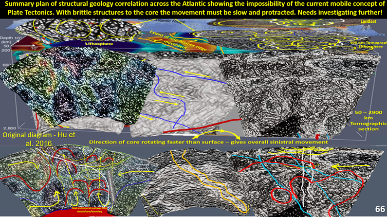
As a participant, you will be the privileged first to take a structural geology of the South American and African continents right down to the core-mantle contact at 2,850 km depth using Landsat, topography, magnetics, gravity and seismic tomographic images of unparalleled detail.
About this event
Participants will gain a broader, but more detailed, insight into the evolution of the Earth and its resources. This will be obtained by examining South America, the Pacific Ocean, Atlantic Ocean and Africa from the surface to the core mantle boundary at 2,900 km depth using ultra enhanced Landsat, topography, magnetics, gravity and seismic tomographic plans and sections.
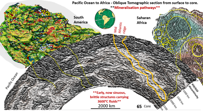
The correlation of mineralisation is obtained by superimposing the mineral locations on the various data plans and correlating them with the sections enabling preliminary exploration targeting. The resource industry has come up against a wall in finding new mineral fields and giant deposits. This new ability to obtain much more detailed deposit formation and location concepts will generate new exploration targets enabling an increase in our discovery rate.
Please note: Registrants who cannot join the webinar at the scheduled time will receive a link to the recording to watch at a later time convenient to them.
Speaker/s

Bob Watchorn
After working in the Kalgoorlie and Norseman gold mines he moved to Stawell playing an important role in restarting the mine. At Stawell he completed an MSc at University of Melbourne on the ‘Structural geology and mineralisation of Stawell goldfield’ under the mentorship of Professor Chris Wilson.
He was chief geologist of the large and geologically complex Mt Magnet and St Ives gold operations. After leaving WMC in 1999 he worked as a geological consultant on many Australian and overseas projects. He commenced structural research under excellent mentors Tim O’Driscoll and Pat McGeehan in the 1980s by experimenting with geophysical software to obtain the best detail out of images used in exploration.
This, combined with his extensive 3D structural knowledge, gained from 45 years underground and surface mapping, led to the point where exceptionable (real) detail could be obtained (for the first time) from many images. This forms the basis of his current research.
Date and Time
12.00pm – 2.00pm (UTC+08:00)
Cost
Non Member $20.00